- Home
- Human resources and technical equipment
Human Resources of Sepahan Jamekar Consulting Engineers
This consultant brings together a group of specialized and experienced personnel at various scientific levels, including PhD, MA, and BA, in various fields, and offers its engineering services by attracting the cooperation of capable university professors and providing various informatics facilities and required scientific resources, such as the most advanced related software and the latest books and technical findings.
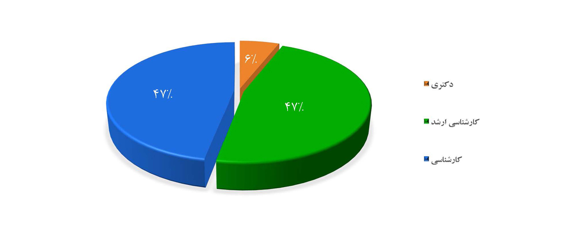
The human resources capability of the company’s headquarters is over 100 efficient people, 6% of whom have a doctorate degree, 47% of whom have a master’s degree, and 47% of whom have a bachelor’s degree.
The average experience of engineers and core employees working with this consultant is more than ten years, which reflects the motivation and satisfaction of the company’s colleagues.
Human Resources Consultant by Education
Consultant facilities and equipment in various departments
- Information Systems
- The most advanced specialized software
- Advanced hardware
Specialized tools and hardware
-
Geotechnical laboratory equipment -
Surveying equipment -
Photography and videography equipment -
Other consultant equipment
- 1. Laboratory sieve: 36 pcs.
- 3. Electric shaker with vibrating timer: 1 unit
- 5. 55 liter oven: 3 pcs.
- 7. Complete consolidation device: 1 piece
- 9. Straight cutting machine: 1 machine
- 11. 200 ton concrete breaker jack: 2 units
- 13. Complete bottle seal equipment: 4 sets
- 15. SPT standard, 10 kg hammer (DIN): 1 unit
- 17. Marshall mold compaction hammer: 1 unit
- 19. Complete set for determining sand value (SE): 4 devices
- 21. Modified compaction mold and hammer: 3 units
- 23. Kerlius drilling machine (D-750): 1 unit
- 25. B-34 drilling rig (mobile): 1 unit
- 27. Cement slurry injection series: 1 series
- 2. Casa Grande Manual: 3 units
- 4. Hydrometric mixer: 1 unit
- 6. Single-axis soil device: 1 piece
- 8. Electric CBR force bearing device: 1 device
- 10. Digital scales: 5 units
- 12. Complete loading equipment: 1 unit
- 14. Soil permeability device: 2 devices
- 16. Manual asphalt construction machine 1500: 1 unit
- 18. Complete Marshall Jack: 1 unit
- 20. Complete Slump Equipment: 4 sets
- 22. Cube mold 15*15: 36 pieces
- 24. Sullivan drilling rig - chassis mounted: 1 unit
- 26. Generator (102-125 KW): 1 unit
- 1. Total Station Camera (LEICA): 2 units
- 2. Nivo Level Finder Camera (NAK2): 2 units
- 3. Niuo Leveling Camera (CST Berger): 8 units
- 4. Positioning device (Majellan): 3 devices
- 5. Wireless (Kenwood): 10 devices
- 6. Handheld GPS (Garmin): More than 150 devices
- 1. Binoculars: 70 units
- 2. Video cameras: 145 units
- 3. Video projector: 1 device
- 1. Radiographic camera model Gamma Volt SU-100
- 2. Radiographic camera model Gammamet TIF
- 3. Radiographic camera model DL-II-A
- 4. Radiographic camera model Tecpas Dlta-880
- 5. Kraut-Kramer ultrasonic device (USK 7D)
- 6. Kraut-Kramer ultrasonic device (USM 25)
- 7. Ultrasonic device model Kraut-Kramer (USN58R)
- 8. Magnetic yoke device Mango Flux model (Y6)
- 9. Mango Flux Magnetic Yoke Machine (Ym5)
- 10. Mango Flux UV Inspection Lamp
- 11. Shinko-Cooper Heat Stress Relief Device
- 12. Penetrating and emerging liquid spray
- 13. Traction machine
- 14. Impact testing machine
- 15. Bending testing machine
- 16. MFI test
- 17. Carbon black measurement test
- 18. Soot (carbon black) distribution measuring device, microscope
- 19. Tensile strength test
- 20. ESCR test for resistance to environmental stresses
- 21. Low Temperature Hydrostatic Pressure Test
- 22. Hydrostatic pressure test at high temperature 80 Burst test (with water)
Specialized software
-
General -
Water and sewage -
Irrigation and drainage -
Dam and tunnel -
Urban planning and architecture -
Road and bridge -
Geographic Information System (GIS)
| Row | Software name | Specific specifications and scope of application |
|---|---|---|
| 1 | Auto Cad | Mapping |
| 2 | Map Source | Finding geographic coordinates |
| 3 | Arc View | GIS reviews |
| 4 | Office | Office administrative matters |
| 5 | Land Development | Drawing topographic and volume maps |
| 6 | Microstation | Estimating the volume of earthworks, determining the route and line of the project, etc. |
| 7 | Tadbir | Project cost estimation |
| Row | Software name | Specific specifications and scope of application |
|---|---|---|
| 1 | Bentley WaterCAD | Design of water distribution and transmission networks |
| 2 | Bentley WaterGEMS | Design of water distribution and transmission networks |
| 3 | Bentley SewerCAD | Design of wastewater collection and transportation network |
| 4 | Bentley SewerGEMS | Design of wastewater collection and transportation network |
| 5 | Bentley HAMMER | Water hammer analysis in pressurized lines |
| 6 | CSDP | Preparing transmission line profiles |
| 7 | SASSPro | Wastewater treatment plant design based on Metcalf 2014 |
| 8 | BITControl Aqua Designer | Designing a wastewater treatment plant based on ATV standards |
| 9 | ESRI ArcGIS | Design and analysis of spatial information systems |
| 10 | Spectrum | Conducting demographic studies |
| 11 | CSI SAP2000 | Structural design and analysis |
| 12 | CSI SAFE | Design and analysis of concrete foundation and slab |
| 13 | Autodesk Civil 3D | Design and drawing of transmission line profiles |
| 14 | Tedkar | Estimating and preparing contract statements |
| 15 | Taksa | Estimating and preparing contract statements |
| Row | Software name | Specific specifications and scope of application |
|---|---|---|
| 1 | Level | Leveling dry lands |
| 2 | TASM | Leveling of paddy fields |
| 3 | Canal | Project profile and line design |
| Row | Software name | Specific specifications and scope of application |
|---|---|---|
| 1 | Land | Preparing volumes and drawing earthworks |
| 2 | CivilDesign | Preparing volumes and drawing earthworks |
| 3 | HecHMS | Performing dam hydraulic processes and calculations |
| 4 | Geo office | Design of earth dam body components using the finite element method |
| 5 | Plaxis | Design of earth dam body components using the finite element method |
| Row | Software name | Specific specifications and scope of application |
|---|---|---|
| 1 | 3DSMAX | 3D design |
| 2 | VRAY | Rendering engine |
| 3 | CORONA RENDERER | Rendering engine |
| 4 | PHOTOSHOP | Poster design and photo editing |
| 5 | RIZOM UNFOLD3D | Creating textures and UV maps |
| 6 | SUBSTANCE PAINTER | Texture painting |
| 7 | KOLOR PANATOUR | Presenting and creating virtual tours |
| Row | Software name | Specific specifications and scope of application |
|---|---|---|
| 1 | CSI Bridge | Structural analysis and design of various types of bridges |
| 2 | Sap 2000 | Analysis and design of various structures (industrial structures, shell structures, etc.) |
| 3 | Etabs | Analysis and design of building structures |
| 4 | Safe | Analysis and design of concrete slabs and foundations |
| 5 | Abaqus | Simulation and analysis of various models using the finite element method |
| 6 | OpenSees | Seismic analysis of structures using the finite element method |
| 7 | Matlab | Advanced technical calculation and charting language |
| 8 | Autodesk Civil 3D | Design and determination of profile and cross-section, Bruckner curve, etc. |
| 9 | +CSDP | Design and determination of profile and cross-section, Bruckner curve, etc. |
| 10 | Land XML2CSDP | Creating outputs and exchanging information between Civil3D and CSDP software |
| 11 | Google Earth | Route layout and control of the accuracy of the location of the studied projects |
| 12 | Global Mapper | Creating preliminary rate curves and converting different data formats to each other |
| 13 | Corel Draw | Design of safety signs and signs used on the route |
| Row | Software name | Specific specifications and scope of application |
|---|---|---|
| 1 | Arc GIS | Working with spatial and descriptive data, performing spatial analyses, managing maps and spatial information in most databases |
| 2 | ENVI | Processing and analyzing information in the field of remote sensing, especially satellite data. |
| 3 | Google Earth | View the world's geographic information, explore the earth, and search for different places. |