
- Home
- Geographic Information System (GIS) Affairs
Geographic Information System (GIS) matters
Specialized studies in Geographic Information System (GIS)
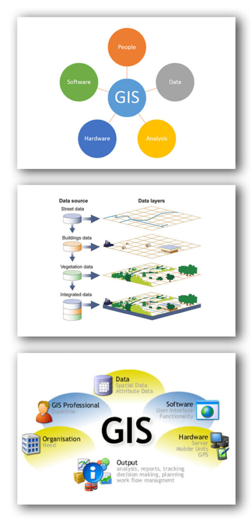
Sepahan Comprehensive Engineering Consulting Company has a 2-level specialization in the field of Geographic Information Systems. Geographic Information Systems (GIS) are a platform for storing, maintaining, managing, and analyzing spatial information. Spatial information systems are considered a useful tool in land data management, which, with the ability to integrate data from different sources, allows for the extraction of required information and the discovery of connections between different features. Since land data is needed in various fields, spatial information systems meet the needs of a wide range of users.
This consulting engineering firm is ready to provide services in the following fields:
1. Design and creation of Geographic Information Systems (GIS) for land (TIS), cadastre, automated mapping and infrastructure management (AM/FM) as well as collection and preparation of spatial information for entry into the geographic information system and cartographic processing and digital drawing of prepared maps. Performing operations of digitizing maps and making spatial data GIS ready. Designing and creating systems that are based on spatial information or technologies, such as LBS, AVL, etc.
2. Providing advice, design and cooperation in the implementation of spatial data infrastructures (SDI). Authoring and compiling thematic, tourist, tourism maps, urban and national guides and atlases. Drawing and presenting all maps, including topography, geography, geology, etc. and other cartographic matters up to the printing stage.
Click to view the featured projects in this section
Summary of the background of a consultant in Geographic Information Systems (GIS)

| Project title | Contract date | Employer |
|---|---|---|
| Implementation of GIS for the water and sewage network in the Khomeini Shahr and Darche regions | 2025/07 | Isfahan Province Water and Wastewater Company |
| Implementation and update of GIS of water and sewage network and subscribers of Falavarjan, Qahdarijan and Abrisham cities | 2024/05 | Isfahan Province Water and Wastewater Company |
| Implementation and update of the second phase of GIS of the water and wastewater network of Isfahan City, Region 3 | 2024/04 | Isfahan Province Water and Wastewater Company |
| Mapping and taking coordinates of manholes of the collection network, transmission lines, and sewage branch siphons with a three-frequency GPS device and preparing a map of its elevation within the cities covered by Abfa West of Tehran Province | 2022/06 | West Tehran Province Water and Wastewater Company |
| Implementation of the GIS project for the water and sewage network of Region 1 of Isfahan | 2022/04 | Isfahan Province Water and Wastewater Company |
| Extraction of spatial and descriptive information of water and wastewater facilities and subscribers in a GIS platform | 2021/07 | Isfahan Province Water and Wastewater Company |
| Implementation of the GIS project for the water and sewage network of the 5th district of Isfahan city | 2020/02 | Isfahan Province Water and Wastewater Company |
| Implementation of the GIS project for the water and sewage network of the 3th district of Isfahan city | 2020/02 | Isfahan Province Water and Wastewater Company |
| Implementation of the GIS project for the water and sewage network in Isfahan City, Region 2 (Phase 2) | 2017/11 | Isfahan Province Water and Wastewater Company |
| Implementation of the GIS project for the water and sewage network of Isfahan's urban area 4 | 2017/11 | Isfahan Province Water and Wastewater Company |
| Creating patrol and inspection groups and surveying water resources and creating a database in a GIS environment | 2015/10 | Isfahan Province Water and Wastewater Company |
| Extraction of spatial data of green space in Isfahan municipality areas GIS (second group) | 2014/11 | Isfahan Municipality |
| Forming patrol, inspection, and monitoring groups and preparing a database in a GIS environment | 2014/08 | Isfahan Province Regional Water Company |
| Implementing mapping operations for all urban uses of Baghbadran roads for basic GIS use | 2014/08 | Municipality of Bagh Bahadaran |
| Forming patrol, inspection, and monitoring groups and preparing a database in a GIS environment | 2013/07 | Isfahan Province Regional Water Company |
| Studies on drinking water supply in Tafresh city and villages in Haftian region using ARC GIS software | 2010/10 | Markazi Province Regional Water Company |
| Study of Geographic Information System (GIS) for the protection and exploitation of water resources | 2009/11 | Mazandaran Province Regional Water Company |
| Geographic Information System (GIS) in the protection and exploitation of groundwater resources | 2008/02 | Mazandaran Province Regional Water Company |
| Water supply plan for Komijan city, Arak, using ARC GIS software | 2007/09 | Markazi Province Regional Water Company |
| Study of the Tangab Semirom Watershed using ARC GIS software | 2007/08 | General Directorate of Natural Resources and Watershed Management of Isfahan Province |